


وصف لـ MapTiler Mobile
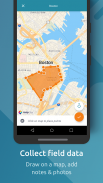
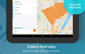
See your GPS position on your own maps. Draw points, polygons and lines on the maps. Collect field data and notes related to a location, attach a photo and fill custom properties.
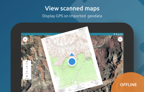
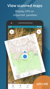
Display offline maps generated with MapTiler (https://www.maptiler.com).
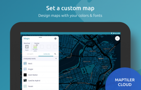
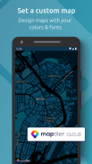
Choose from various basemaps like street and satellite. Preview on a mobile device the map you previously designed with own colors and fonts in MapTiler Cloud.
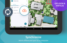
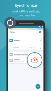
The app supports GeoJSON and MBTiles formats and data synchronization between multiple devices and desktop computer using cloud. I it easy to share the data with other people and collaborate! Perfect for mobile data collection for GIS and surveys.
Import scanned hiking maps, PDF maps, drone aerial imagery, nautical charts for sailing and navigation with a boat or a yacht, fishing maps, aeronautical charts for flight planning by pilots, parcels and city plans and other opendata from local government. OpenStreetMap vector maps are powered by OpenMapTiles project (the successor of OSM2VectorTiles). Maps can come from existing tile servers with OGC WMTS, TileJSON or XYZ tiles from.
Supported geodata formats by MapTiler: GeoTIFF, TIFF, JPEG, ECW, SID / MrSID, NOAA KAP / BSB, DEM, OziExplorer OZI OZF2 & OZFX3, WebP, JP2, JPEG2000, GeoJP2, Erdas, Grass, Safe, Sentinel2, SRTM, NASA imagery, USGS map sheets, exports from ESRI ArcGIS, ArcSDE, etc.
The GeoJSON can be converted from / to: ESRI ShapeFile (SHP), DXF, DWG, GPX, CSV and KML.
رؤية موقف GPS الخاص بك على الخرائط الخاصة بك. ارسم نقاط ومضلعات وخطوط على الخرائط. جمع بيانات الحقل والملاحظات المتعلقة بموقع ، وإرفاق صورة وملء الخصائص المخصصة.
عرض الخرائط غير المتصلة التي تم إنشاؤها باستخدام MapTiler (https://www.maptiler.com).
اختر من خرائط الأساس المختلفة مثل الشارع والأقمار الصناعية. قم بمعاينة الخريطة التي قمت بتصميمها مسبقًا على جهاز محمول بألوان وخطوط خاصة في MapTiler Cloud.
يدعم التطبيق تنسيقات GeoJSON و MBTiles ومزامنة البيانات بين أجهزة متعددة وجهاز كمبيوتر سطح المكتب باستخدام السحابة. من السهل مشاركة البيانات مع أشخاص آخرين والتعاون! مثالية لجمع البيانات المتنقلة لنظام المعلومات الجغرافية والدراسات الاستقصائية.
استيراد خرائط المشي لمسافات طويلة الممسوحة ضوئيًا وخرائط PDF وصور جوية بدون طيار وخرائط بحرية للإبحار والتنقل باستخدام قارب أو يخت وخرائط لصيد الأسماك ومخططات طيران لتخطيط الرحلات من قبل الطيارين والطرود وخطط المدن وغيرها من خطط العمل من الحكومة المحلية. يتم تشغيل خرائط متجه OpenStreetMap بواسطة مشروع OpenMapTiles (خليفة OSM2VectorTiles). يمكن أن تأتي الخرائط من خوادم التجانب الموجودة مع بلاط OGC WMTS أو TileJSON أو XYZ.
تنسيقات البيانات الجغرافية المدعومة بواسطة MapTiler: GeoTIFF و TIFF و JPEG و ECW و SID / MrSID و NOAA KAP / BSB و DEM و OziExplorer OZI OZF2 و OZFX3 و WebP و JP2 و JPEG2000 و GeoJP2 و Erdas و Grass و Safe و SentinelA SR الصور ، أوراق خرائط USGS ، الصادرات من ESRI ArcGIS ، ArcSDE ، إلخ.
يمكن تحويل GeoJSON من / إلى: ESRI ShapeFile (SHP) و DXF و DWG و GPX و CSV و KML.
MapTiler Mobile - إصدار 2.0.1
(12-03-2020)MapTiler Mobile - معلومات APK
نُسخة APK: 2.0.1الحزمة: com.maptiler.geoeditorتطبيقات من الفئة نفسها
قد يعجبك أيضًا...


